 Facebook
 Twitter
 Pinterest
 LinkedIn
 Email
Email Copy Link
 WhatsApp
 Messenger

- KES4,294,967,295
- Business
- For Sale
- Kericho
 Kenya
Kenya
CHECK IF AVAILABLE
CHECK IF AVAILABLE
The Estate
Geographic features & Photographs around the estate, in Rift Valley, Kenya stream;a body of running water moving to a lower level in a channel on land.
Kiptariet (7.3km)
Kaparuso (7.3km)
Tugunon (8.2km)
Kipchoriet (15.6km)
Kibinges (15.6km)
Timbilil (18.7km)
Namuting (22km)
Malaget (22km)
Dionsoyiet (23.6km)
Kaboswa (26.1km)
Kaptanjua (31.2km)
Chetumu (31.3km)
Kipkwes (31.7km)
Nyambisoin (33km)
Kaptabal (34.9km)
tea plantation_kericho, kenya. school;building(s) where instruction in one or more branches of knowledge takes place.
Buchenge (3.7km)
Chebigen (3.7km)
Kaboloin (10.4km)
Poiywak (16.5km)
Keongo (18.4km)
Kapsigario (22.2km)
Cheribo (25.9km)
Telanet (29.8km)
Kaptebeswet (31.6km)
Borborwet (34.1km)
tea plantation_kericho, kenya populated place;a city, town, village, or other agglomeration of buildings where people live and work.
Kapkiam (3.7km)
Kapsaos (5.2km)
Ainamoi (18.5km)
Fort Ternan (22.3km)
Kericho (23.6km)
Lumbwa (31.2km)
Kapsamonget (33.5km)
Kapsoit (33.5km)
Koru (33.9km)
Kenegut (34km)
Flame Tree at Tea Hotel, Garden estate(s);a large commercialized agricultural landholding with associated buildings and other facilities.
Estate (0km)
Kapkatungor Estate (7.4km)
Kapkorech Estate (8.2km)
Chomogondy Estate (14.7km)
Kimugu Estate (15.6km)
Soasa Estate (28km)
Kapsongoi Estate (28.8km)
Changana Estate (32.9km)
Kokwet Estate (33.2km)
Kericho Tea Estate (34km)
Strong Man Tree administrative division;an administrative division of a country, undifferentiated as to administrative level.
Kapsaus Sub-Location (10.4km)
Ainamoi Sub-Location (14.8km)
Poiywek Sub-Location (19.9km)
Upper Belgut Location (28.1km)
Accommodation around The lingLuck Hotels
Availability and lone tree in the tea. area;a tract of land without homogeneous character or boundaries.
Kecheriet (31.5km)
Kimugul (34.8km)
Koyabei (34.8km)
Peeping at the tea through the clouds waterfall(s) a perpendicular or very steep descent of the water of a ng Falls (30.3km) Christmas Falls (33.9km) Kericho, Kenya railroad station;a facility comprising ticket office, platforms, etc. for loading and unloading train passengers and l (18.3km)
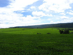
The green carpet of tea airport;a place where aircraft regularly land and take off, with runways, navigational aids, and major facilities for the commercial handling of passengers and ho (15.1km)Tea plantation workers housing, Kericho, Kenya mission;a place characterized by dwellings, school, church, hospital and other facilities operated by a religious group for the purpose of providing charitable services and to propagate religion.
Kipchimchim (23.4km)
Guardian Bus Services - ;a rounded elevation of limited extent rising above the surrounding land with local relief of less than 300m.
Kapsoit (34.1km)forest station;
a collection of buildings and facilities for carrying out forest management. Kericho Forest Station (11km) peak;a pointed elevation atop a mountain, ridge, or other hypsographic el (30.5km) forest(s);an area dominated by tree rn Mau Forest (18.8km).
Muhoroni city city o
Londiani city city o
Litein city city o
Molo, Kenya city city o
Kisumu District adm2nd adm2nd
Ahero city city o
Bomet city city o
Eldama Ravine city city o
Metkei city city o
Kapsabet city city o
Kisumu city city d
Dawsonville, Kenya city city o
Nakuru city city d
Kisii, Kenya city city o
Nakurusee waterbody lake
Nyahururu city city o
Geographic features & Photographs around the estate, in Rift Valley, Kenya stream;a body of running water moving to a lower level in a channel on land.
Kiptariet (7.3km)
Kaparuso (7.3km)
Tugunon (8.2km)
Kipchoriet (15.6km)
Kibinges (15.6km)
Timbilil (18.7km)
Namuting (22km)
Malaget (22km)
Dionsoyiet (23.6km)
Kaboswa (26.1km)
Kaptanjua (31.2km)
Chetumu (31.3km)
Kipkwes (31.7km)
Nyambisoin (33km)
Kaptabal (34.9km)
tea plantation_kericho, kenya. school;building(s) where instruction in one or more branches of knowledge takes place.
Buchenge (3.7km)
Chebigen (3.7km)
Kaboloin (10.4km)
Poiywak (16.5km)
Keongo (18.4km)
Kapsigario (22.2km)
Cheribo (25.9km)
Telanet (29.8km)
Kaptebeswet (31.6km)
Borborwet (34.1km)
tea plantation_kericho, kenya populated place;a city, town, village, or other agglomeration of buildings where people live and work.
Kapkiam (3.7km)
Kapsaos (5.2km)
Ainamoi (18.5km)
Fort Ternan (22.3km)
Kericho (23.6km)
Lumbwa (31.2km)
Kapsamonget (33.5km)
Kapsoit (33.5km)
Koru (33.9km)
Kenegut (34km)
Flame Tree at Tea Hotel, Garden estate(s);a large commercialized agricultural landholding with associated buildings and other facilities.
Estate (0km)
Kapkatungor Estate (7.4km)
Kapkorech Estate (8.2km)
Chomogondy Estate (14.7km)
Kimugu Estate (15.6km)
Soasa Estate (28km)
Kapsongoi Estate (28.8km)
Changana Estate (32.9km)
Kokwet Estate (33.2km)
Kericho Tea Estate (34km)
Strong Man Tree administrative division;an administrative division of a country, undifferentiated as to administrative level.
Kapsaus Sub-Location (10.4km)
Ainamoi Sub-Location (14.8km)
Poiywek Sub-Location (19.9km)
Upper Belgut Location (28.1km)
Accommodation around The lingLuck Hotels
Availability and lone tree in the tea. area;a tract of land without homogeneous character or boundaries.
Kecheriet (31.5km)
Kimugul (34.8km)
Koyabei (34.8km)
Peeping at the tea through the clouds waterfall(s) a perpendicular or very steep descent of the water of a ng Falls (30.3km) Christmas Falls (33.9km) Kericho, Kenya railroad station;a facility comprising ticket office, platforms, etc. for loading and unloading train passengers and l (18.3km)
The green carpet of tea airport;a place where aircraft regularly land and take off, with runways, navigational aids, and major facilities for the commercial handling of passengers and ho (15.1km)Tea plantation workers housing, Kericho, Kenya mission;a place characterized by dwellings, school, church, hospital and other facilities operated by a religious group for the purpose of providing charitable services and to propagate religion.
Kipchimchim (23.4km)
Guardian Bus Services - ;a rounded elevation of limited extent rising above the surrounding land with local relief of less than 300m.
Kapsoit (34.1km)forest station;
a collection of buildings and facilities for carrying out forest management. Kericho Forest Station (11km) peak;a pointed elevation atop a mountain, ridge, or other hypsographic el (30.5km) forest(s);an area dominated by tree rn Mau Forest (18.8km).
Muhoroni city city o
Londiani city city o
Litein city city o
Molo, Kenya city city o
Kisumu District adm2nd adm2nd
Ahero city city o
Bomet city city o
Eldama Ravine city city o
Metkei city city o
Kapsabet city city o
Kisumu city city d
Dawsonville, Kenya city city o
Nakuru city city d
Kisii, Kenya city city o
Nakurusee waterbody lake
Nyahururu city city o
The Estate
Geographic features & Photographs around the estate, in Rift Valley, Kenya stream;a body of running water moving to a lower level in a channel on land.
Kiptariet (7.3km)
Kaparuso (7.3km)
Tugunon (8.2km)
Kipchoriet (15.6km)
Kibinges (15.6km)
Timbilil (18.7km)
Namuting (22km)
Malaget ...
Geographic features & Photographs around the estate, in Rift Valley, Kenya stream;a body of running water moving to a lower level in a channel on land.
Kiptariet (7.3km)
Kaparuso (7.3km)
Tugunon (8.2km)
Kipchoriet (15.6km)
Kibinges (15.6km)
Timbilil (18.7km)
Namuting (22km)
Malaget ...
View more
CHECK IF AVAILABLE